Iztapalapa
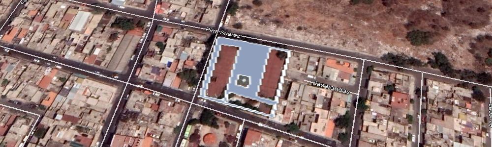
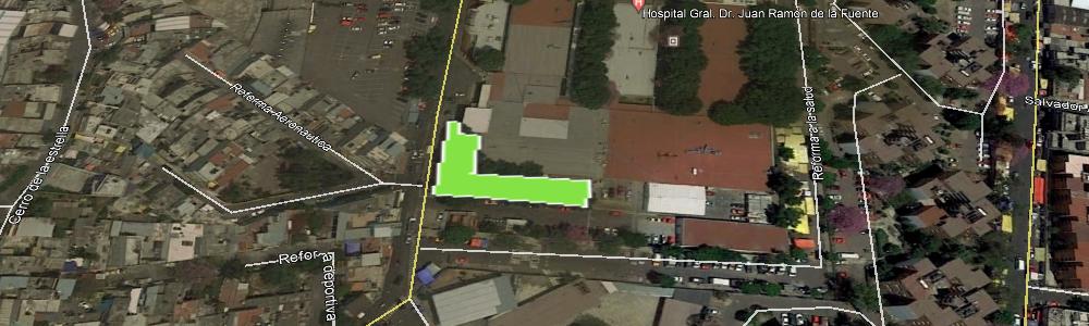
| Nombre del área verde: | PARQUE (1748) |
|
Mapa: |
Ver |
| Dirección: | C. 6 CARLOS MANCILLA MZ20 LT26 |
Superficie: | 7,020.60 m2 |
| Colonia: | U.H. VICENTE GUERRERO |
Perímetro: | 399.32 m2 |
| Código postal: | 09200 |
Programa: | |
| Subclasificación: | Parques |
Decreto: | |
| Clasificación: | Parques, arboledas y alamedas |
Revegetada: | -, 0000-00-00 |
 |
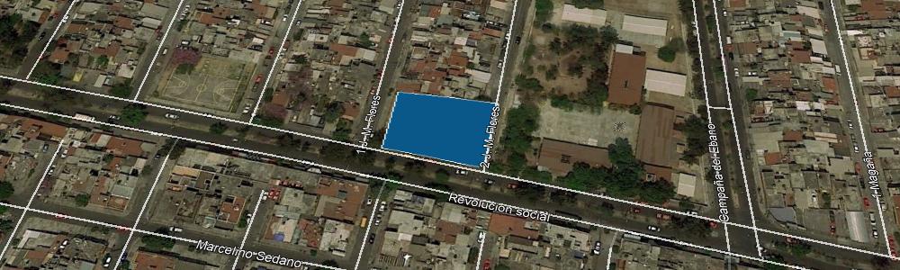
| Nombre del área verde: | PARQUE (1749) |
|
Mapa: |
Ver |
| Dirección: | AV. REVOLUCIÓN SOC. Y C. 2 E.ROSAS |
Superficie: | 1,082.82 m2 |
| Colonia: | U.H. VICENTE GUERRERO |
Perímetro: | 133.55 m2 |
| Código postal: | 09200 |
Programa: | |
| Subclasificación: | Parques |
Decreto: | |
| Clasificación: | Parques, arboledas y alamedas |
Revegetada: | -, 0000-00-00 |
 |
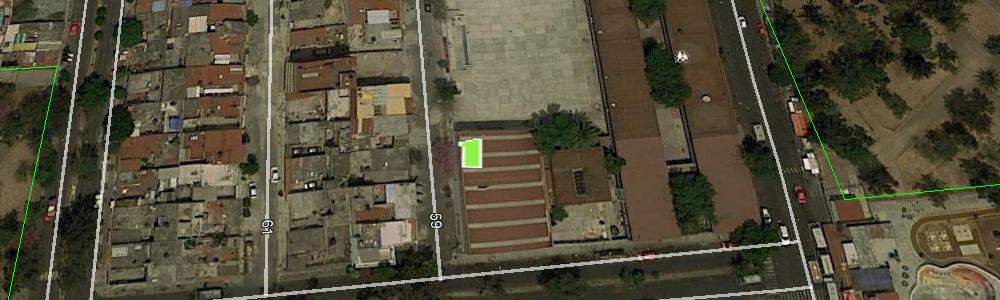
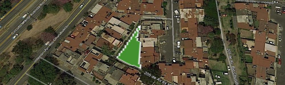
| Nombre del área verde: | CONALEP IZTAPALAPA III (207) |
|
Mapa: |
Ver |
| Dirección: | CIRUELO Y CALLE NAUTLA |
Superficie: | 2,025.15 m2 |
| Colonia: | SAN JUAN XALPA |
Perímetro: | 727.09 m2 |
| Código postal: | 09850 |
Programa: | |
| Subclasificación: | Parques |
Decreto: | |
| Clasificación: | Parques, arboledas y alamedas |
Revegetada: | -, 0000-00-00 |
 |
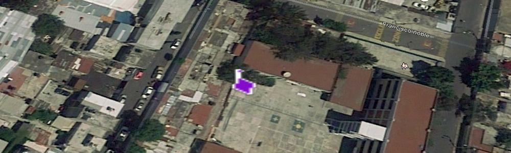
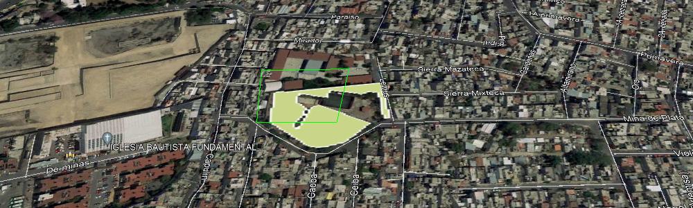
| Nombre del área verde: | CLUB DEPORTIVO - CANCHAS DE BÁSQUETBOL Y FÚTBOL (1751) |
|
Mapa: |
Ver |
| Dirección: | C. 4 FRANCISCO MENA 3A |
Superficie: | 4,529.29 m2 |
| Colonia: | U.H. VICENTE GUERRERO |
Perímetro: | 468.69 m2 |
| Código postal: | 09200 |
Programa: | |
| Subclasificación: | Instituciones académicas públicas |
Decreto: | |
| Clasificación: | Equipamientos urbanos con vegetación |
Revegetada: | -, 0000-00-00 |
 |
| Nombre del área verde: | CAMELLON SIERVO DE LA NACIÓN (1135) |
|
Mapa: |
Ver |
| Dirección: | SIERVO DE LA NACIÓN |
Superficie: | 353.05 m2 |
| Colonia: | ERMITA ZARAGOZA |
Perímetro: | 235.34 m2 |
| Código postal: | 09180 |
Programa: | |
| Subclasificación: | Unidades habitacionales |
Decreto: | |
| Clasificación: | Equipamientos urbanos con vegetación |
Revegetada: | -, 0000-00-00 |
 |
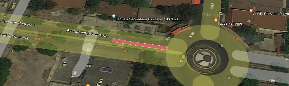
| Nombre del área verde: | CAMELLON AV. HERMINIO CHAVARRÍA (825) |
|
Mapa: |
Ver |
| Dirección: | AV. HERMINIO CHAVARRÍA Y CALLE MIGUEL HIDALGO |
Superficie: | 77.63 m2 |
| Colonia: | ZONA URBANA EJIDAL SANTA MARÍA AZTAHUACAN |
Perímetro: | 89.15 m2 |
| Código postal: | 09570 |
Programa: | |
| Subclasificación: | Instituciones académicas públicas |
Decreto: | |
| Clasificación: | Equipamientos urbanos con vegetación |
Revegetada: | -, 0000-00-00 |
 |
| Nombre del área verde: | CAMELLON SIERVO DE LA NACIÓN (1134) |
|
Mapa: |
Ver |
| Dirección: | SIERVO DE LA NACIÓN Y AV. TEXCOCO |
Superficie: | 340.36 m2 |
| Colonia: | ERMITA ZARAGOZA |
Perímetro: | 195.25 m2 |
| Código postal: | 09180 |
Programa: | |
| Subclasificación: | Unidades habitacionales |
Decreto: | |
| Clasificación: | Equipamientos urbanos con vegetación |
Revegetada: | -, 0000-00-00 |
 |
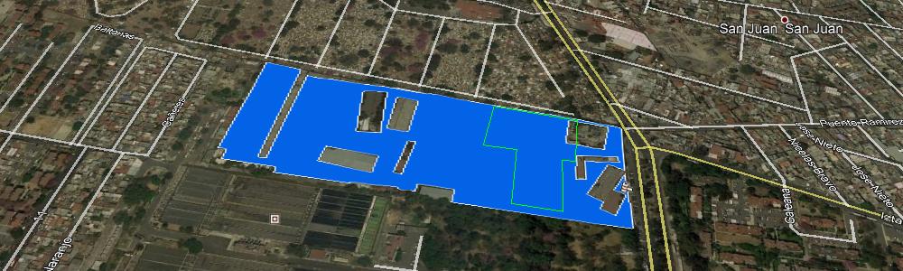
| Nombre del área verde: | UNIDAD HABITACINAL (1754) |
|
Mapa: |
Ver |
| Dirección: | C. 3 ALBERTO HERNÁNDEZ Y ANILLO PERIFERICO |
Superficie: | 5,791.69 m2 |
| Colonia: | U.H. VICENTE GUERRERO |
Perímetro: | 1,430.58 m2 |
| Código postal: | 09200 |
Programa: | |
| Subclasificación: | Unidades habitacionales |
Decreto: | |
| Clasificación: | Equipamientos urbanos con vegetación |
Revegetada: | -, 0000-00-00 |
 |
| Nombre del área verde: | UNIDAD HABITACINAL (1755) |
|
Mapa: |
Ver |
| Dirección: | C. 1 F. MENA Y CAMPAÑA DEL ÉBANO |
Superficie: | 1,198.92 m2 |
| Colonia: | U.H. VICENTE GUERRERO |
Perímetro: | 389.88 m2 |
| Código postal: | 09200 |
Programa: | |
| Subclasificación: | Parques |
Decreto: | |
| Clasificación: | Parques, arboledas y alamedas |
Revegetada: | -, 0000-00-00 |
 |
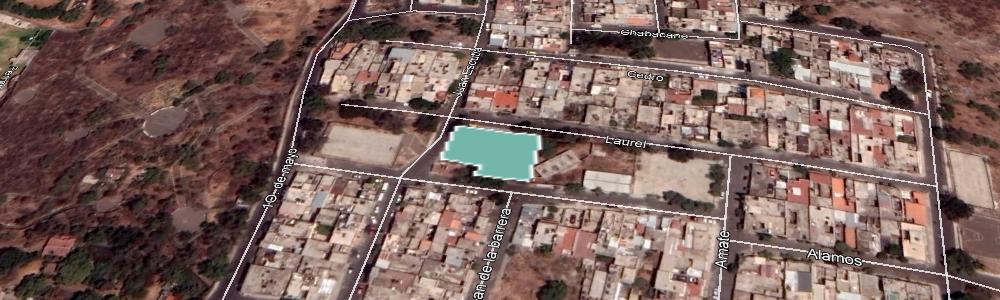
| Nombre del área verde: | ESCUELA SECUNDARIA TÉCNICA N° 103 (2195) |
|
Mapa: |
Ver |
| Dirección: | LAUREL ENTRE ÁLAMOS Y DEL ROSAL IZTAPALAPA |
Superficie: | 49.15 m2 |
| Colonia: | CAMPESTRE POTRERO |
Perímetro: | 36.71 m2 |
| Código postal: | 09637 |
Programa: | |
| Subclasificación: | Parques |
Decreto: | |
| Clasificación: | Parques, arboledas y alamedas |
Revegetada: | -, 0000-00-00 |
 |
| Nombre del área verde: | PLANTA DE TRATAMIENTO DE AGUAS RESIDUALES CERRO DE LA ESTRELLA (204) |
|
Mapa: |
Ver |
| Dirección: | AV. SAN LORENZO |
Superficie: | 42,883.62 m2 |
| Colonia: | SAN JUAN XALPA |
Perímetro: | 3,939.19 m2 |
| Código postal: | 09850 |
Programa: | |
| Subclasificación: | Unidades habitacionales |
Decreto: | |
| Clasificación: | Equipamientos urbanos con vegetación |
Revegetada: | -, 0000-00-00 |
 |
| Nombre del área verde: | ESCUELA PRIMARIA AGUSTÍN YÁÑEZ (935) |
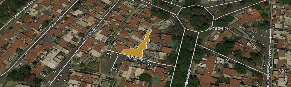
|
Mapa: |
Ver |
| Dirección: | CONTADORES 143 |
Superficie: | 949.97 m2 |
| Colonia: | NUEVA ROSITA |
Perímetro: | 125.28 m2 |
| Código postal: | 09420 |
Programa: | |
| Subclasificación: | Unidades habitacionales |
Decreto: | |
| Clasificación: | Equipamientos urbanos con vegetación |
Revegetada: | -, 0000-00-00 |
 |
| Nombre del área verde: | UNIDAD HABITACINAL (1757) |
|
Mapa: |
Ver |
| Dirección: | AV. ANTONIO DÍAZ SOTO Y GAMA |
Superficie: | 224.33 m2 |
| Colonia: | U.H. VICENTE GUERRERO |
Perímetro: | 100.74 m2 |
| Código postal: | 09200 |
Programa: | |
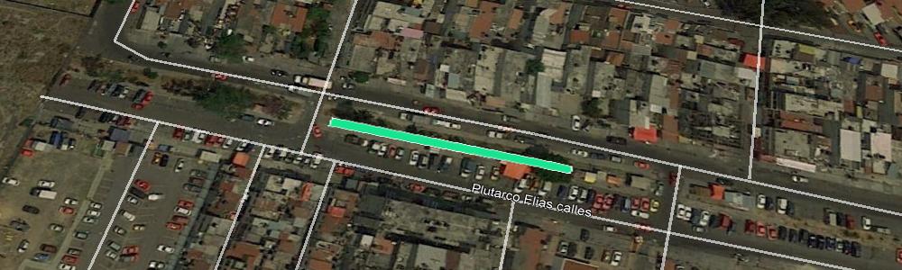
| Subclasificación: | Parques |
Decreto: | |
| Clasificación: | Parques, arboledas y alamedas |
Revegetada: | -, 0000-00-00 |
 |
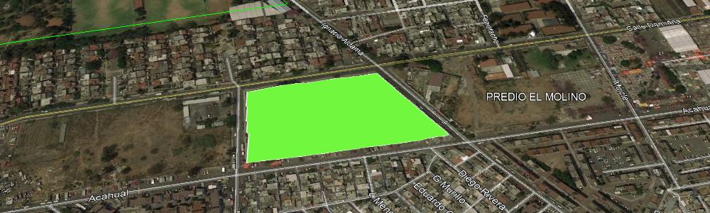
| Nombre del área verde: | PARQUE DEPORTIVO LEAH KATIUSKA URIBE S (2) |
|
Mapa: |
Ver |
| Dirección: | ACAHUATL Y MACAHUITE |
Superficie: | 16,891.41 m2 |
| Colonia: | PREDIO EL MOLINO |
Perímetro: | 552.62 m2 |
| Código postal: | 09960 |
Programa: | |
| Subclasificación: | Parques |
Decreto: | |
| Clasificación: | Parques, arboledas y alamedas |
Revegetada: | -, 0000-00-00 |
 |
| Nombre del área verde: | PARQUE BANDERA (613) |
|
Mapa: |
Ver |
| Dirección: | BANDERA 14 |
Superficie: | 864.13 m2 |
| Colonia: | ZONA URBANA EJIDAL SAN ANDRÉS TOMATLAN |
Perímetro: | 138.24 m2 |
| Código postal: | 09870 |
Programa: | |
| Subclasificación: | Parques |
Decreto: | |
| Clasificación: | Parques, arboledas y alamedas |
Revegetada: | -, 0000-00-00 |
 |
| Nombre del área verde: | UNIDAD HABITACINAL (1758) |
|
Mapa: |
Ver |
| Dirección: | AV. ANTONIO DÍAZ SOTO Y GAMA |
Superficie: | 228.77 m2 |
| Colonia: | U.H. VICENTE GUERRERO |
Perímetro: | 116.10 m2 |
| Código postal: | 09200 |
Programa: | |
| Subclasificación: | Unidades habitacionales |
Decreto: | |
| Clasificación: | Equipamientos urbanos con vegetación |
Revegetada: | -, 0000-00-00 |
 |
| Nombre del área verde: | UNIDAD HABITACIONAL ALCANFORES (202) |
|
Mapa: |
Ver |
| Dirección: | AV. SAN LORENZO Y ESTRELLA |
Superficie: | 2,330.57 m2 |
| Colonia: | VALLE DE SAN LORENZO |
Perímetro: | 783.21 m2 |
| Código postal: | 09850 |
Programa: | |
| Subclasificación: | Jardines públicos |
Decreto: | |
| Clasificación: | Plazas y jardines |
Revegetada: | -, 0000-00-00 |
 |
| Nombre del área verde: | JARDINERAS (614) |
|
Mapa: |
Ver |
| Dirección: | BANDERA 14 |
Superficie: | 687.47 m2 |
| Colonia: | ZONA URBANA EJIDAL SAN ANDRÉS TOMATLAN |
Perímetro: | 137.65 m2 |
| Código postal: | 09870 |
Programa: | |
| Subclasificación: | Unidades habitacionales |
Decreto: | |
| Clasificación: | Equipamientos urbanos con vegetación |
Revegetada: | -, 0000-00-00 |
 |
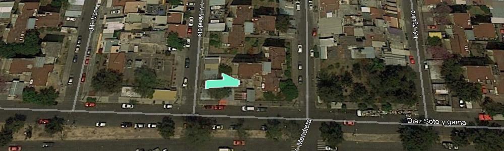
| Nombre del área verde: | UNIDAD HABITACINAL (1760) |
|
Mapa: |
Ver |
| Dirección: | AV. ANTONIO DÍAZ SOTO Y GAMA Y C. 1 VICENTE MENDIETA |
Superficie: | 43.37 m2 |
| Colonia: | U.H. VICENTE GUERRERO |
Perímetro: | 28.75 m2 |
| Código postal: | 09200 |
Programa: | |
| Subclasificación: | Unidades habitacionales |
Decreto: | |
| Clasificación: | Equipamientos urbanos con vegetación |
Revegetada: | -, 0000-00-00 |
 |
| Nombre del área verde: | CAMELLON AV. TLAHUAC (615) |
|
Mapa: |
Ver |
| Dirección: | AV. TLAHUAC Y AV. STA. ANA |
Superficie: | 177.06 m2 |
| Colonia: | ZONA URBANA EJIDAL SAN ANDRÉS TOMATLAN |
Perímetro: | 66.54 m2 |
| Código postal: | 09870 |
Programa: | |
| Subclasificación: | Unidades habitacionales |
Decreto: | |
| Clasificación: | Equipamientos urbanos con vegetación |
Revegetada: | -, 0000-00-00 |
 |
| Nombre del área verde: | UNIDAD HABITACINAL (1762) |
|
Mapa: |
Ver |
| Dirección: | AV. ANTONIO DÍAZ SOTO Y GAMA Y C. 2 RODOLFO AGUIRRE |
Superficie: | 127.51 m2 |
| Colonia: | U.H. VICENTE GUERRERO |
Perímetro: | 71.06 m2 |
| Código postal: | 09200 |
Programa: | |
| Subclasificación: | Unidades habitacionales |
Decreto: | |
| Clasificación: | Equipamientos urbanos con vegetación |
Revegetada: | -, 0000-00-00 |
 |
| Nombre del área verde: | UNIDAD HABITACINAL (1763) |
|
Mapa: |
Ver |
| Dirección: | AV. ANTONIO DÍAZ SOTO Y GAMA Y C. 2 RODOLFO AGUIRRE |
Superficie: | 605.95 m2 |
| Colonia: | U.H. VICENTE GUERRERO |
Perímetro: | 205.93 m2 |
| Código postal: | 09200 |
Programa: | |
| Subclasificación: | Unidades habitacionales |
Decreto: | |
| Clasificación: | Equipamientos urbanos con vegetación |
Revegetada: | -, 0000-00-00 |
 |
| Nombre del área verde: | UNIDAD HABITACINAL (1764) |
|
Mapa: |
Ver |
| Dirección: | AV. ANTONIO DÍAZ SOTO Y GAMA Y C. 2 DIMAS ESTRADA |
Superficie: | 298.79 m2 |
| Colonia: | U.H. VICENTE GUERRERO |
Perímetro: | 174.82 m2 |
| Código postal: | 09200 |
Programa: | |
| Subclasificación: | Parques |
Decreto: | |
| Clasificación: | Parques, arboledas y alamedas |
Revegetada: | -, 0000-00-00 |
 |
| Nombre del área verde: | ESCUELA SECUNDARIA TÉCNICA N° 103 (2196) |
|
Mapa: |
Ver |
| Dirección: | LAUREL ENTRE ÁLAMOS Y DEL ROSAL IZTAPALAPA |
Superficie: | 155.04 m2 |
| Colonia: | CAMPESTRE POTRERO |
Perímetro: | 77.59 m2 |
| Código postal: | 09637 |
Programa: | |
| Subclasificación: | Parques |
Decreto: | |
| Clasificación: | Parques, arboledas y alamedas |
Revegetada: | -, 0000-00-00 |
 |
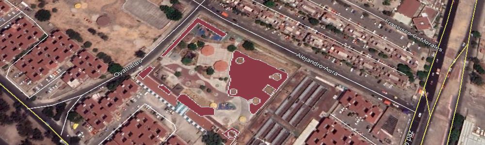
| Nombre del área verde: | PARQUE INFANTIL PATOLLI EL SALADO (1129) |
|
Mapa: |
Ver |
| Dirección: | OYAMELES Y A ALEJANDRO AURA |
Superficie: | 2,835.08 m2 |
| Colonia: | ÁREA FEDERAL PARQUE ECOLÓGICO EL SALADO |
Perímetro: | 730.69 m2 |
| Código postal: | 09140 |
Programa: | |
| Subclasificación: | Parques |
Decreto: | |
| Clasificación: | Parques, arboledas y alamedas |
Revegetada: | -, 0000-00-00 |
 |
| Nombre del área verde: | CAMELLON AV. HERMINIO CHAVARRÍA (834) |
|
Mapa: |
Ver |
| Dirección: | AV. HERMINIO CHAVARRÍA Y PLAN DE AYALA |
Superficie: | 80.57 m2 |
| Colonia: | ZONA URBANA EJIDAL SANTA MARÍA AZTAHUACAN |
Perímetro: | 70.35 m2 |
| Código postal: | 09570 |
Programa: | |
| Subclasificación: | Parques |
Decreto: | |
| Clasificación: | Parques, arboledas y alamedas |
Revegetada: | -, 0000-00-00 |
 |
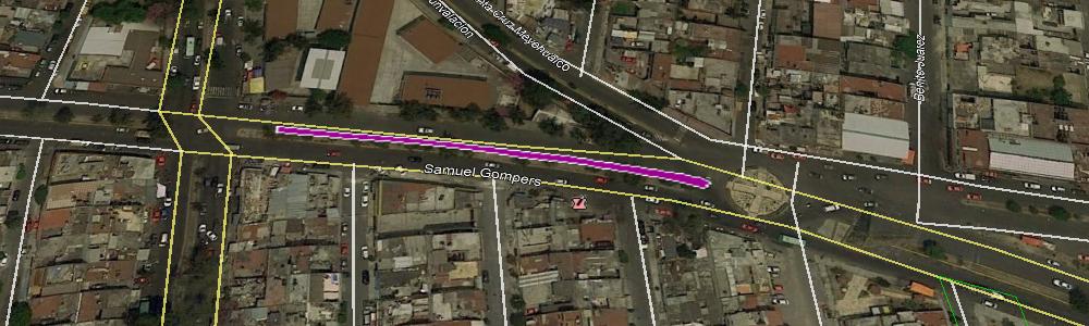
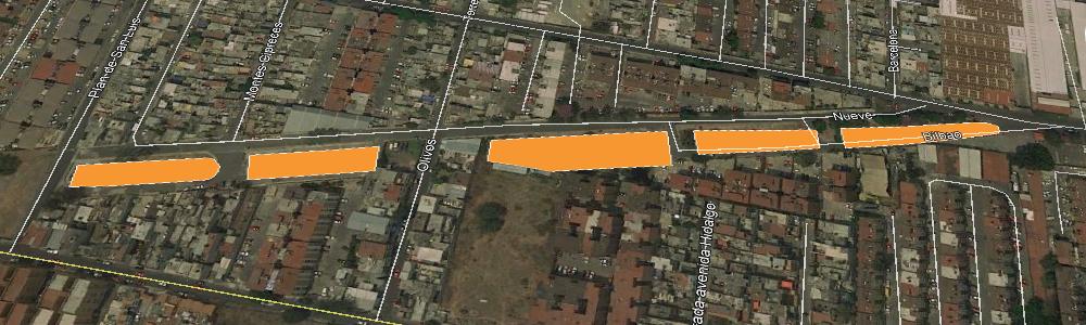
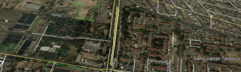
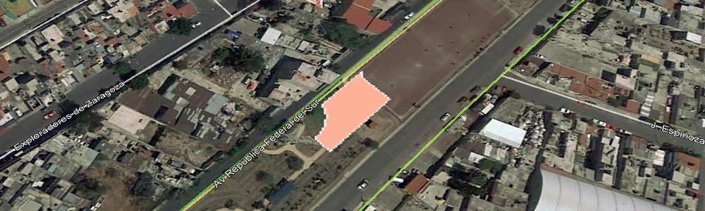
| Nombre del área verde: | CAMELLON AV. IGNACIO ALDAMA (17) |
|
Mapa: |
Ver |
| Dirección: | AV. IGNACIO ALDAMA Y ZACAHUITZCO |
Superficie: | 1,511.13 m2 |
| Colonia: | SAN LORENZO |
Perímetro: | 1,743.67 m2 |
| Código postal: | 09940 |
Programa: | |
| Subclasificación: | Deportivos |
Decreto: | |
| Clasificación: | Equipamientos urbanos con vegetación |
Revegetada: | -, 0000-00-00 |
 |
| Nombre del área verde: | ÁREAS VERDES (199) |
|
Mapa: |
Ver |
| Dirección: | CALZ. DE LA VIGA Y PROL. EMILIANO ZAPATA |
Superficie: | 315.30 m2 |
| Colonia: | MODELO |
Perímetro: | 82.36 m2 |
| Código postal: | 09089 |
Programa: | |
| Subclasificación: | Unidades habitacionales |
Decreto: | |
| Clasificación: | Equipamientos urbanos con vegetación |
Revegetada: | -, 0000-00-00 |
 |
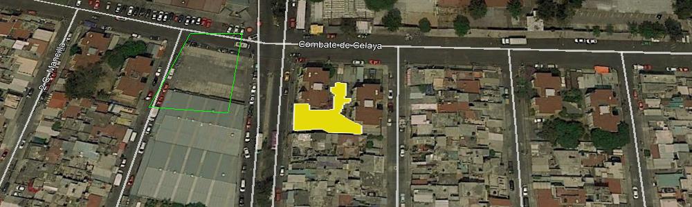
| Nombre del área verde: | CENTRO DE ESTUDIOS TECNOLÓGICOS INDUSTRIAL Y DE SERVICIOS NÚM. 53 (1766) |
|
Mapa: |
Ver |
| Dirección: | COMBATE DE CELAYA S/N |
Superficie: | 7,468.73 m2 |
| Colonia: | U.H. VICENTE GUERRERO |
Perímetro: | 1,220.77 m2 |
| Código postal: | 09200 |
Programa: | |
| Subclasificación: | Instituciones académicas públicas |
Decreto: | |
| Clasificación: | Equipamientos urbanos con vegetación |
Revegetada: | -, 0000-00-00 |
 |
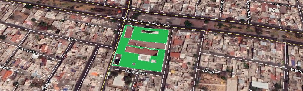
| Nombre del área verde: | ESCUELA PRIMARIA PROFR. ENRIQUE GONZÁLEZ APARICIO (1767) |
|
Mapa: |
Ver |
| Dirección: | AV. DE LAS TORRES MZ531 LT15 |
Superficie: | 3,982.04 m2 |
| Colonia: | SAN MIGUEL TEOTONGO |
Perímetro: | 836.35 m2 |
| Código postal: | 09630 |
Programa: | |
| Subclasificación: | Parques |
Decreto: | |
| Clasificación: | Parques, arboledas y alamedas |
Revegetada: | -, 0000-00-00 |
 |
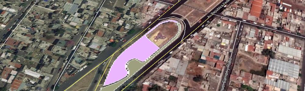
| Nombre del área verde: | PARQUE UNIÓN SOVIÉTICA (617) |
|
Mapa: |
Ver |
| Dirección: | AV. REPÚBLICA FEDERAL DEL NTE, Y PAULINO MARTÍNEZ |
Superficie: | 2,282.01 m2 |
| Colonia: | ZONA URBANA EJIDAL SANTA MARTHA ACATITLA NTE |
Perímetro: | 222.24 m2 |
| Código postal: | 09140 |
Programa: | |
| Subclasificación: | Deportivos |
Decreto: | |
| Clasificación: | Equipamientos urbanos con vegetación |
Revegetada: | -, 0000-00-00 |
 |
| Nombre del área verde: | CAMELLON CALZ. DE LA VIGA (198) |
|
Mapa: |
Ver |
| Dirección: | CALZ. DE LA VIGA |
Superficie: | 2,418.74 m2 |
| Colonia: | MODELO |
Perímetro: | 487.59 m2 |
| Código postal: | 09089 |
Programa: | |
| Subclasificación: | Terrenos baldíos |
Decreto: | |
| Clasificación: | Áreas verdes urbanas fragmentadas |
Revegetada: | -, 0000-00-00 |
 |
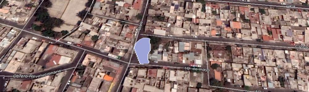
| Nombre del área verde: | TERRENO BALDÍO (1769) |
|
Mapa: |
Ver |
| Dirección: | ÉBANO Y CAOBA |
Superficie: | 278.89 m2 |
| Colonia: | SAN MIGUEL TEOTONGO |
Perímetro: | 71.01 m2 |
| Código postal: | 09630 |
Programa: | |
| Subclasificación: | Parques |
Decreto: | |
| Clasificación: | Parques, arboledas y alamedas |
Revegetada: | -, 0000-00-00 |
 |
| Nombre del área verde: | ESCUELA SECUNDARIA DIURNA 267 TEODORO FLORES (1770) |
|
Mapa: |
Ver |
| Dirección: | C. ELOY CAVAZOS Y AV. DE LAS TORRES |
Superficie: | 2,579.12 m2 |
| Colonia: | SAN MIGUEL TEOTONGO |
Perímetro: | 614.87 m2 |
| Código postal: | 09630 |
Programa: | |
| Subclasificación: | Parques |
Decreto: | |
| Clasificación: | Parques, arboledas y alamedas |
Revegetada: | -, 0000-00-00 |
 |
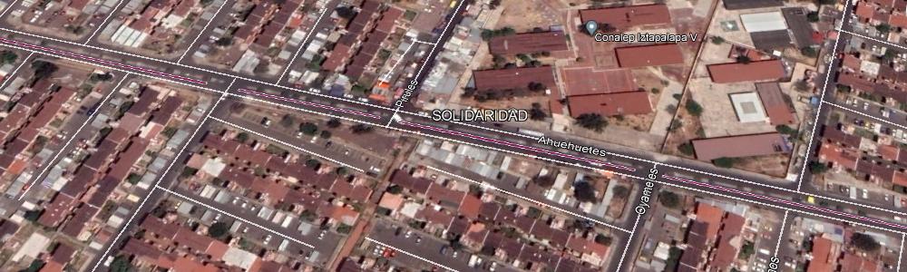
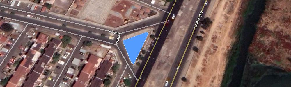
| Nombre del área verde: | CAMELLON AHUEHUETES (1125) |
|
Mapa: |
Ver |
| Dirección: | AHUEHUETES Y OCTAVIO PAZ |
Superficie: | 321.68 m2 |
| Colonia: | SOLIDARIDAD |
Perímetro: | 80.34 m2 |
| Código postal: | 09160 |
Programa: | |
| Subclasificación: | Parques |
Decreto: | |
| Clasificación: | Parques, arboledas y alamedas |
Revegetada: | -, 0000-00-00 |
 |
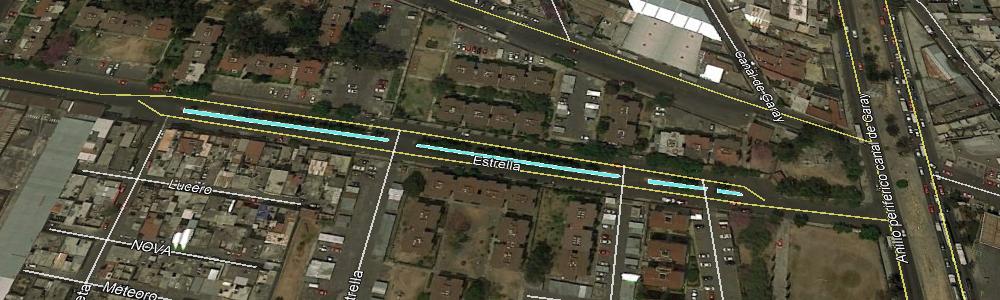
| Nombre del área verde: | CAMELLON ESTRELLA (196) |
|
Mapa: |
Ver |
| Dirección: | ESTRELLA Y IZTACCIHUATL |
Superficie: | 722.09 m2 |
| Colonia: | SAN LORENZO TEZONCO |
Perímetro: | 252.17 m2 |
| Código postal: | 09839 |
Programa: | |
| Subclasificación: | Parques |
Decreto: | |
| Clasificación: | Parques, arboledas y alamedas |
Revegetada: | -, 0000-00-00 |
 |
| Nombre del área verde: | PARQUE (1772) |
|
Mapa: |
Ver |
| Dirección: | CLAVEL Y ORQUÍDEA |
Superficie: | 720.16 m2 |
| Colonia: | SAN MIGUEL TEO |
Perímetro: | 109.62 m2 |
| Código postal: | 09630 |
Programa: | |
| Subclasificación: | Parques |
Decreto: | |
| Clasificación: | Parques, arboledas y alamedas |
Revegetada: | -, 0000-00-00 |
 |
| Nombre del área verde: | FONDO DE CULTURA ECONÓMICA - FARO DE ORIENTE (1124) |
|
Mapa: |
Ver |
| Dirección: | AV. ZARAGOZA S/N, CEDROS Y PINOS |
Superficie: | 5,550.12 m2 |
| Colonia: | FUENTES DE ZARAGOZA |
Perímetro: | 469.30 m2 |
| Código postal: | 09150 |
Programa: | |
| Subclasificación: | Instituciones académicas públicas |
Decreto: | |
| Clasificación: | Equipamientos urbanos con vegetación |
Revegetada: | -, 0000-00-00 |
 |
| Nombre del área verde: | CAMELLON ESTRELLA (195) |
|
Mapa: |
Ver |
| Dirección: | ESTRELLA Y COMETA |
Superficie: | 424.61 m2 |
| Colonia: | SAN LORENZO TEZONCO |
Perímetro: | 457.58 m2 |
| Código postal: | 09839 |
Programa: | |
| Subclasificación: | Parques |
Decreto: | |
| Clasificación: | Parques, arboledas y alamedas |
Revegetada: | -, 0000-00-00 |
 |
| Nombre del área verde: | PARQUE (620) |
|
Mapa: |
Ver |
| Dirección: | AV. REPÚBLICA FEDERAL DEL NTE. |
Superficie: | 303.10 m2 |
| Colonia: | ZONA URBANA EJIDAL SANTA MARTHA ACATITLA NTE. |
Perímetro: | 75.19 m2 |
| Código postal: | 09140 |
Programa: | |
| Subclasificación: | Parques |
Decreto: | |
| Clasificación: | Parques, arboledas y alamedas |
Revegetada: | -, 0000-00-00 |
 |
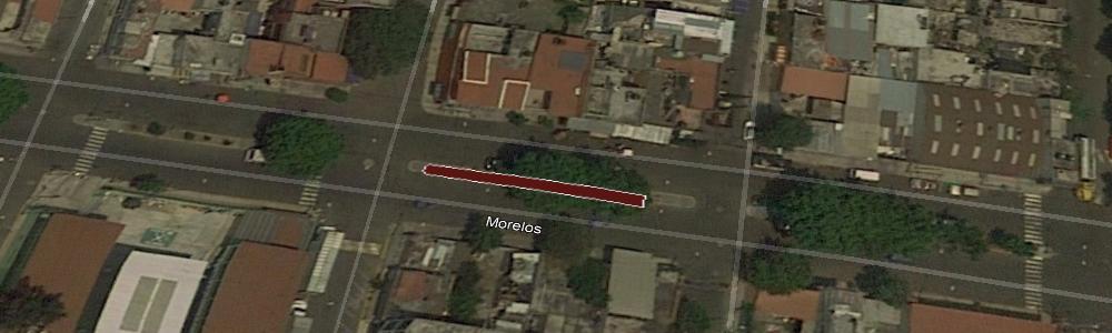
| Nombre del área verde: | CAMELLON AVENIDA MORELOS (853) |
|
Mapa: |
Ver |
| Dirección: | AVENIDA MORELOS Y JOSEFA ORTIZ DE DOMÍNGUEZ |
Superficie: | 73.91 m2 |
| Colonia: | STA MARÍA AZTAHUACAN |
Perímetro: | 75.82 m2 |
| Código postal: | 09500 |
Programa: | |
| Subclasificación: | Parques |
Decreto: | |
| Clasificación: | Parques, arboledas y alamedas |
Revegetada: | -, 0000-00-00 |
 |
| Nombre del área verde: | PARQUE (621) |
|
Mapa: |
Ver |
| Dirección: | AV. REPÚBLICA FEDERAL DEL NTE. |
Superficie: | 538.17 m2 |
| Colonia: | ZONA URBANA EJIDAL SANTA MARTHA ACATITLA NTE. |
Perímetro: | 295.61 m2 |
| Código postal: | 09140 |
Programa: | |
| Subclasificación: | Parques |
Decreto: | |
| Clasificación: | Parques, arboledas y alamedas |
Revegetada: | -, 0000-00-00 |
 |
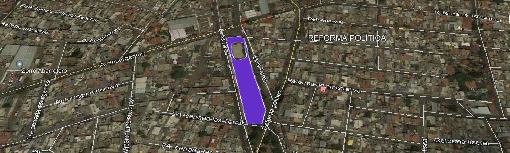
| Nombre del área verde: | PARQUE (1122) |
|
Mapa: |
Ver |
| Dirección: | AV. DE LAS TORRES |
Superficie: | 2,552.11 m2 |
| Colonia: | REFORMA POLÍTICA |
Perímetro: | 433.86 m2 |
| Código postal: | 09730 |
Programa: | |
| Subclasificación: | Parques |
Decreto: | |
| Clasificación: | Parques, arboledas y alamedas |
Revegetada: | -, 0000-00-00 |
 |
| Nombre del área verde: | CAMELLON AV. STA CRUZ MEYEHUALCO (792) |
|
Mapa: |
Ver |
| Dirección: | AV. STA CRUZ MEYEHUALCO Y C. 17 |
Superficie: | 453.38 m2 |
| Colonia: | SANTA MARÍA AZTAHUACAN |
Perímetro: | 374.26 m2 |
| Código postal: | 09570 |
Programa: | |
| Subclasificación: | Parques |
Decreto: | |
| Clasificación: | Parques, arboledas y alamedas |
Revegetada: | -, 0000-00-00 |
 |
| Nombre del área verde: | JARDÍN DE NIÑOS TLAMATINI (1779) |
|
Mapa: |
Ver |
| Dirección: | FELIPE ÁNGELES |
Superficie: | 1,693.71 m2 |
| Colonia: | SAN MIGUEL TEOTONGO |
Perímetro: | 479.28 m2 |
| Código postal: | 09630 |
Programa: | |
| Subclasificación: | Parques |
Decreto: | |
| Clasificación: | Parques, arboledas y alamedas |
Revegetada: | -, 0000-00-00 |
 |
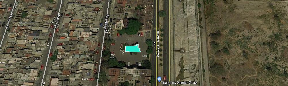
| Nombre del área verde: | LECHERÍA LICONSA (192) |
|
Mapa: |
Ver |
| Dirección: | RAMÓN L. VELARDE 17 |
Superficie: | 515.73 m2 |
| Colonia: | SAN JUAN |
Perímetro: | 129.94 m2 |
| Código postal: | 09839 |
Programa: | |
| Subclasificación: | Parques |
Decreto: | |
| Clasificación: | Parques, arboledas y alamedas |
Revegetada: | -, 0000-00-00 |
 |
| Nombre del área verde: | FUENTE DE AGUA POTABLE (1780) |
|
Mapa: |
Ver |
| Dirección: | SARABIA Y JAZMÍN |
Superficie: | 473.63 m2 |
| Colonia: | SAN MIGUEL TEOTONGO |
Perímetro: | 160.32 m2 |
| Código postal: | 09630 |
Programa: | |
| Subclasificación: | Parques |
Decreto: | |
| Clasificación: | Parques, arboledas y alamedas |
Revegetada: | -, 0000-00-00 |
 |
| Nombre del área verde: | JARDÍN DE NIÑOS TLAYOLLI (1781) |
|
Mapa: |
Ver |
| Dirección: | VERACRUZ Y NARDOS |
Superficie: | 506.18 m2 |
| Colonia: | SAN MIGUEL TEOTONGO |
Perímetro: | 431.91 m2 |
| Código postal: | 09630 |
Programa: | |
| Subclasificación: | Parques |
Decreto: | |
| Clasificación: | Parques, arboledas y alamedas |
Revegetada: | -, 0000-00-00 |
 |
| Nombre del área verde: | PARQUE (191) |
|
Mapa: |
Ver |
| Dirección: | GRAL. SOSA Y PLUTARCO ELÍAS CALLES |
Superficie: | 284.58 m2 |
| Colonia: | 2DA AMP SAN JUAN |
Perímetro: | 86.68 m2 |
| Código postal: | 09858 |
Programa: | |
| Subclasificación: | Terrenos baldíos |
Decreto: | |
| Clasificación: | Áreas verdes urbanas fragmentadas |
Revegetada: | -, 0000-00-00 |
 |
| Nombre del área verde: | ESCUELA PRIMARIA UGANDA (1783) |
|
Mapa: |
Ver |
| Dirección: | CALLE VICENTE GUERRERO Y C. NARDO |
Superficie: | 1,910.72 m2 |
| Colonia: | SAN MIGUEL TEOTONGO |
Perímetro: | 456.18 m2 |
| Código postal: | 09630 |
Programa: | |
| Subclasificación: | Parques |
Decreto: | |
| Clasificación: | Parques, arboledas y alamedas |
Revegetada: | -, 0000-00-00 |
 |
| Nombre del área verde: | PARQUE (1120) |
|
Mapa: |
Ver |
| Dirección: | AV. DE LAS TORRES |
Superficie: | 2,038.56 m2 |
| Colonia: | REFORMA POLÍTICA |
Perímetro: | 561.03 m2 |
| Código postal: | 09730 |
Programa: | |
| Subclasificación: | Parques |
Decreto: | |
| Clasificación: | Parques, arboledas y alamedas |
Revegetada: | -, 0000-00-00 |
 |
| Nombre del área verde: | CAMELLON CANAL RÍO CHURUBUSCO (929) |
|
Mapa: |
Ver |
| Dirección: | CANAL RÍO CHURUBUSCO |
Superficie: | 2,373.93 m2 |
| Colonia: | SAN JOSÉ ACULCO |
Perímetro: | 344.58 m2 |
| Código postal: | 09410 |
Programa: | |
| Subclasificación: | Parques |
Decreto: | |
| Clasificación: | Parques, arboledas y alamedas |
Revegetada: | -, 0000-00-00 |
 |
| Nombre del área verde: | PARQUE (190) |
|
Mapa: |
Ver |
| Dirección: | CALZ. DE LA VIGA |
Superficie: | 1,787.88 m2 |
| Colonia: | SECTOR POPULAR, HÉROES DE CHURUBUSCO |
Perímetro: | 308.39 m2 |
| Código postal: | 09060 |
Programa: | |
| Subclasificación: | Parques |
Decreto: | |
| Clasificación: | Parques, arboledas y alamedas |
Revegetada: | -, 0000-00-00 |
 |
| Nombre del área verde: | ESCUELA SECUNDARIA TÉCNICA N° 103 (2198) |
|
Mapa: |
Ver |
| Dirección: | LAUREL ENTRE ÁLAMOS Y DEL ROSAL IZTAPALAPA |
Superficie: | 97.30 m2 |
| Colonia: | CAMPESTRE POTRERO |
Perímetro: | 56.18 m2 |
| Código postal: | 09637 |
Programa: | |
| Subclasificación: | Instituciones académicas públicas |
Decreto: | |
| Clasificación: | Equipamientos urbanos con vegetación |
Revegetada: | -, 0000-00-00 |
 |
| Nombre del área verde: | ESCUELA PRIMARIA REPÚBLICA DE GUINEA (189) |
|
Mapa: |
Ver |
| Dirección: | RAFAEL SIERRA 52 |
Superficie: | 532.42 m2 |
| Colonia: | SAN JUAN |
Perímetro: | 259.25 m2 |
| Código postal: | 09830 |
Programa: | |
| Subclasificación: | Parques |
Decreto: | |
| Clasificación: | Parques, arboledas y alamedas |
Revegetada: | -, 0000-00-00 |
 |
| Nombre del área verde: | PARQUE (625) |
|
Mapa: |
Ver |
| Dirección: | AV. REPÚBLICA FEDERAL DEL NTE |
Superficie: | 1,128.40 m2 |
| Colonia: | ZONA URBANA EJIDAL SANTA MARTHA ACATITLA |
Perímetro: | 416.67 m2 |
| Código postal: | 09140 |
Programa: | |
| Subclasificación: | Panteones |
Decreto: | |
| Clasificación: | Equipamientos urbanos con vegetación |
Revegetada: | -, 0000-00-00 |
 |
| Nombre del área verde: | ESCUELA PRIMARIA ALEJANDRO VOLTA (1786) |
|
Mapa: |
Ver |
| Dirección: | C. ELOY CAVAZOS S/N |
Superficie: | 5,407.13 m2 |
| Colonia: | SAN MIGUEL TEOTONGO |
Perímetro: | 854.42 m2 |
| Código postal: | 09630 |
Programa: | |
| Subclasificación: | Parques |
Decreto: | |
| Clasificación: | Parques, arboledas y alamedas |
Revegetada: | -, 0000-00-00 |
 |
| Nombre del área verde: | DEPORTIVO HÉRCULES (1787) |
|
Mapa: |
Ver |
| Dirección: | AV CAPULÍN MZ44 LT1 |
Superficie: | 2,437.46 m2 |
| Colonia: | SAN MIGUEL TEOTONGO |
Perímetro: | 374.87 m2 |
| Código postal: | 09630 |
Programa: | |
| Subclasificación: | Unidades habitacionales |
Decreto: | |
| Clasificación: | Equipamientos urbanos con vegetación |
Revegetada: | -, 0000-00-00 |
 |
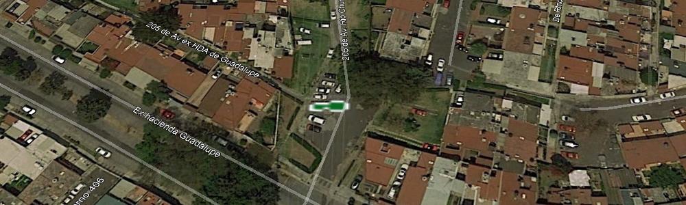
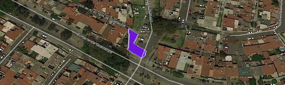
| Nombre del área verde: | UNIDAD HABITACIONAL (188) |
|
Mapa: |
Ver |
| Dirección: | EX-HACIENDA GUADALUPE |
Superficie: | 25.29 m2 |
| Colonia: | MODELO |
Perímetro: | 23.76 m2 |
| Código postal: | 09250 |
Programa: | |
| Subclasificación: | Parques |
Decreto: | |
| Clasificación: | Parques, arboledas y alamedas |
Revegetada: | -, 0000-00-00 |
 |
| Nombre del área verde: | ÁREAS VERDES (928) |
|
Mapa: |
Ver |
| Dirección: | CANAL RÍO CHURUBUSCO Y FRUTAS Y LEGUMBRES |
Superficie: | 312.90 m2 |
| Colonia: | SAN JOSÉ ACULCO |
Perímetro: | 98.19 m2 |
| Código postal: | 09410 |
Programa: | |
| Subclasificación: | Parques |
Decreto: | |
| Clasificación: | Parques, arboledas y alamedas |
Revegetada: | -, 0000-00-00 |
 |
| Nombre del área verde: | PARQUE (626) |
|
Mapa: |
Ver |
| Dirección: | AV. REPÚBLICA FEDERAL DEL NTE |
Superficie: | 1,868.74 m2 |
| Colonia: | ZONA URBANA EJIDAL SANTA MARTHA ACATITLA |
Perímetro: | 327.31 m2 |
| Código postal: | 09140 |
Programa: | |
| Subclasificación: | Parques |
Decreto: | |
| Clasificación: | Parques, arboledas y alamedas |
Revegetada: | -, 0000-00-00 |
 |
| Nombre del área verde: | CAMELLON AV. STA. CRUZ MEYEHUALCO (793) |
|
Mapa: |
Ver |
| Dirección: | AV. STA. CRUZ MEYEHUALCO |
Superficie: | 293.76 m2 |
| Colonia: | SANTA CRUZ MEYEHUALCO |
Perímetro: | 234.59 m2 |
| Código postal: | 09290 |
Programa: | |
| Subclasificación: | Parques |
Decreto: | |
| Clasificación: | Parques, arboledas y alamedas |
Revegetada: | -, 0000-00-00 |
 |
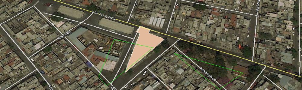
| Nombre del área verde: | PARQUE (50) |
|
Mapa: |
Ver |
| Dirección: | C. VILLA FRANQUEZA Y TLILALPACATL |
Superficie: | 737.57 m2 |
| Colonia: | DESARROLLO URBANO QUETZALCÓATL |
Perímetro: | 147.12 m2 |
| Código postal: | 09700 |
Programa: | |
| Subclasificación: | Parques |
Decreto: | |
| Clasificación: | Parques, arboledas y alamedas |
Revegetada: | -, 0000-00-00 |
 |
| Nombre del área verde: | PARQUE (1789) |
|
Mapa: |
Ver |
| Dirección: | PALOMA Y CALANDRIA |
Superficie: | 430.96 m2 |
| Colonia: | SAN MIGUEL TEOTONGO |
Perímetro: | 94.70 m2 |
| Código postal: | 09630 |
Programa: | |
| Subclasificación: | Parques |
Decreto: | |
| Clasificación: | Parques, arboledas y alamedas |
Revegetada: | -, 0000-00-00 |
 |
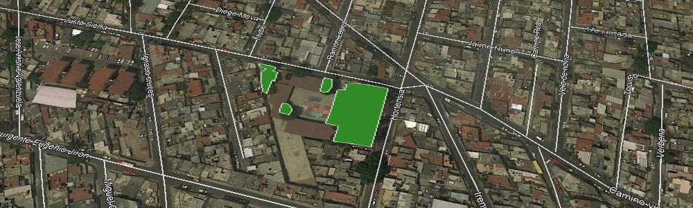
| Nombre del área verde: | PARQUE (16) |
|
Mapa: |
Ver |
| Dirección: | JDN. HORTENSIAS Y AV. CUAUHTÉMOC |
Superficie: | 1,893.83 m2 |
| Colonia: | JARDINES DE SAN LORENZO TEZONCO |
Perímetro: | 181.54 m2 |
| Código postal: | 09940 |
Programa: | |
| Subclasificación: | Unidades habitacionales |
Decreto: | |
| Clasificación: | Equipamientos urbanos con vegetación |
Revegetada: | -, 0000-00-00 |
 |
| Nombre del área verde: | UNIDAD HABITACIONAL (187) |
|
Mapa: |
Ver |
| Dirección: | EX-HACIENDA GUADALUPE |
Superficie: | 203.71 m2 |
| Colonia: | MODELO |
Perímetro: | 76.51 m2 |
| Código postal: | 09250 |
Programa: | |
| Subclasificación: | Parques |
Decreto: | |
| Clasificación: | Parques, arboledas y alamedas |
Revegetada: | -, 0000-00-00 |
 |
| Nombre del área verde: | CAMELLON CANAL RÍO CHURUBUSCO (927) |
|
Mapa: |
Ver |
| Dirección: | CANAL RÍO CHURUBUSCO |
Superficie: | 3,761.61 m2 |
| Colonia: | SAN JOSÉ ACULCO |
Perímetro: | 563.89 m2 |
| Código postal: | 09410 |
Programa: | |
| Subclasificación: | Unidades habitacionales |
Decreto: | |
| Clasificación: | Equipamientos urbanos con vegetación |
Revegetada: | -, 0000-00-00 |
 |
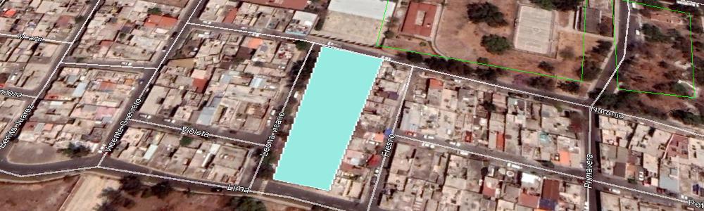
| Nombre del área verde: | UNIDAD HABITACIONAL XACALLI (1791) |
|
Mapa: |
Ver |
| Dirección: | CANAL DE CHALCO Y C. CANAL DE GARAY |
Superficie: | 30,189.45 m2 |
| Colonia: | TRIÁNGULO DE LAS AGUJAS I Y II |
Perímetro: | 5,856.72 m2 |
| Código postal: | 09885 |
Programa: | |
| Subclasificación: | Unidades habitacionales |
Decreto: | |
| Clasificación: | Equipamientos urbanos con vegetación |
Revegetada: | -, 0000-00-00 |
 |
| Nombre del área verde: | CAMELLON ANILLO PERIF. - CANAL DE GARAY (186) |
|
Mapa: |
Ver |
| Dirección: | ANILLO PERIF. - CANAL DE GARAY |
Superficie: | 18,969.02 m2 |
| Colonia: | CASA BLANCA |
Perímetro: | 2,100.34 m2 |
| Código postal: | 09860 |
Programa: | |
| Subclasificación: | Unidades habitacionales |
Decreto: | |
| Clasificación: | Equipamientos urbanos con vegetación |
Revegetada: | -, 0000-00-00 |
 |
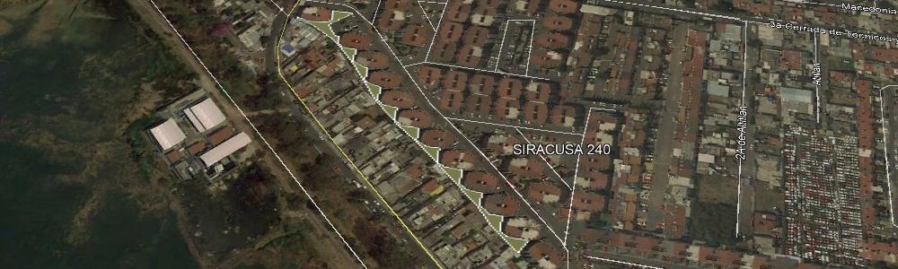
| Nombre del área verde: | UNIDAD HABITACIONAL (1793) |
|
Mapa: |
Ver |
| Dirección: | ESTRELLA DEL SUR Y CANAL DE CHALCO |
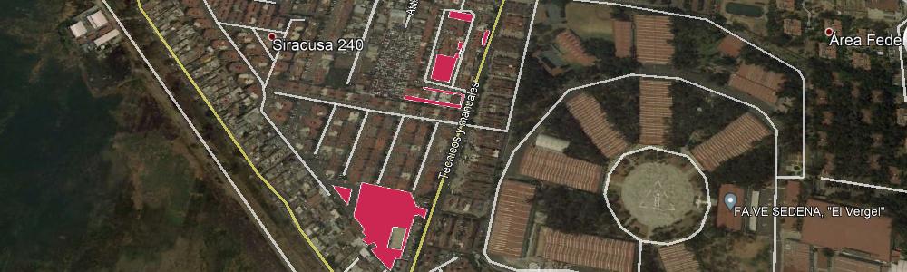
Superficie: | 1,340.46 m2 |
| Colonia: | SIRACUSA 240 |
Perímetro: | 647.38 m2 |
| Código postal: | 09897 |
Programa: | |
| Subclasificación: | Unidades habitacionales |
Decreto: | |
| Clasificación: | Equipamientos urbanos con vegetación |
Revegetada: | -, 0000-00-00 |
 |
| Nombre del área verde: | CAMELLON AV. PUENTE RAMÍREZ (184) |
|
Mapa: |
Ver |
| Dirección: | AV. PUENTE RAMÍREZ |
Superficie: | 186.74 m2 |
| Colonia: | LOS ÁNGELES |
Perímetro: | 66.93 m2 |
| Código postal: | 09830 |
Programa: | |
| Subclasificación: | Unidades habitacionales |
Decreto: | |
| Clasificación: | Equipamientos urbanos con vegetación |
Revegetada: | -, 0000-00-00 |
 |
| Nombre del área verde: | UNIDAD HABITACIONAL (1796) |
|
Mapa: |
Ver |
| Dirección: | CARTAGO Y MORELOS |
Superficie: | 2,214.36 m2 |
| Colonia: | LOMAS ESTRELLA 2DA SECC |
Perímetro: | 1,202.50 m2 |
| Código postal: | 09890 |
Programa: | |
| Subclasificación: | Parques |
Decreto: | |
| Clasificación: | Parques, arboledas y alamedas |
Revegetada: | -, 0000-00-00 |
 |
| Nombre del área verde: | FACULTAD DE ESTUDIOS SUPERIORES ZARAGOZA UNAM CAMPUS II (630) |
|
Mapa: |
Ver |
| Dirección: | BATALLA 5 DE MAYO SN |
Superficie: | 55,383.81 m2 |
| Colonia: | EJÉRCITO DE ORIENTE ZONA PEÑÓN |
Perímetro: | 4,934.45 m2 |
| Código postal: | 09230 |
Programa: | |
| Subclasificación: | Parques |
Decreto: | |
| Clasificación: | Parques, arboledas y alamedas |
Revegetada: | -, 0000-00-00 |
 |
| Nombre del área verde: | CAMELLON CANAL RÍO CHURUBUSCO (925) |
|
Mapa: |
Ver |
| Dirección: | CANAL RÍO CHURUBUSCO |
Superficie: | 2,045.32 m2 |
| Colonia: | SAN JOSÉ ACULCO |
Perímetro: | 345.18 m2 |
| Código postal: | 09410 |
Programa: | |
| Subclasificación: | Unidades habitacionales |
Decreto: | |
| Clasificación: | Equipamientos urbanos con vegetación |
Revegetada: | -, 0000-00-00 |
 |
| Nombre del área verde: | UNIDAD HABITACIONAL (1797) |
|
Mapa: |
Ver |
| Dirección: | LUSITANIA Y SIRACUSA |
Superficie: | 6,297.66 m2 |
| Colonia: | LOMAS ESTRELLA 2DA SECC. |
Perímetro: | 1,439.10 m2 |
| Código postal: | 09890 |
Programa: | |
| Subclasificación: | Unidades habitacionales |
Decreto: | |
| Clasificación: | Equipamientos urbanos con vegetación |
Revegetada: | -, 0000-00-00 |
 |
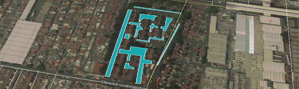
| Nombre del área verde: | CAMELLON CALLE MORELOS (CINEMATOGRAFISTAS) (1798) |
|
Mapa: |
Ver |
| Dirección: | CALLE MORELOS (CINEMATOGRAFISTAS) |
Superficie: | 242.21 m2 |
| Colonia: | LOMAS ESTRELLA 2DA. SECC. |
Perímetro: | 188.89 m2 |
| Código postal: | 09890 |
Programa: | |
| Subclasificación: | Parques |
Decreto: | |
| Clasificación: | Parques, arboledas y alamedas |
Revegetada: | -, 0000-00-00 |
 |
| Nombre del área verde: | DEPORTIVO REBECA (1113) |
|
Mapa: |
Ver |
| Dirección: | ORO Y COLORÍN |
Superficie: | 2,941.62 m2 |
| Colonia: | 2DA AMP SANTIAGO ACAHUAL |
Perímetro: | 427.29 m2 |
| Código postal: | 09609 |
Programa: | |
| Subclasificación: | Deportivos |
Decreto: | |
| Clasificación: | Equipamientos urbanos con vegetación |
Revegetada: | -, 0000-00-00 |
 |
| Nombre del área verde: | ESCUELA DE FORMACIÓN DEPORTIVA SALVADOR ALLENDE (1799) |
|
Mapa: |
Ver |
| Dirección: | DÍAZ SOTO Y GAMA S/N |
Superficie: | 7,972.36 m2 |
| Colonia: | U.H. VICENTE GUERRERO |
Perímetro: | 1,143.24 m2 |
| Código postal: | 09200 |
Programa: | |
| Subclasificación: | Instituciones académicas públicas |
Decreto: | |
| Clasificación: | Equipamientos urbanos con vegetación |
Revegetada: | -, 0000-00-00 |
 |
| Nombre del área verde: | ESCUELA PRIMARIA MAESTRO DOMINGO TIRADO BENEDI (182) |
|
Mapa: |
Ver |
| Dirección: | RAFAEL SIERRA |
Superficie: | 1,799.10 m2 |
| Colonia: | SAN JUAN |
Perímetro: | 301.58 m2 |
| Código postal: | 09830 |
Programa: | |
| Subclasificación: | Parques |
Decreto: | |
| Clasificación: | Parques, arboledas y alamedas |
Revegetada: | -, 0000-00-00 |
 |
| Nombre del área verde: | CAMELLON AV. HERMINIO CHAVARRÍA (826) |
|
Mapa: |
Ver |
| Dirección: | AV. HERMINIO CHAVARRÍA |
Superficie: | 17.13 m2 |
| Colonia: | ZONA URBANA EJIDAL SANTA MARÍA AZTAHUACAN |
Perímetro: | 21.53 m2 |
| Código postal: | 09570 |
Programa: | |
| Subclasificación: | Parques |
Decreto: | |
| Clasificación: | Parques, arboledas y alamedas |
Revegetada: | -, 0000-00-00 |
 |
| Nombre del área verde: | ESCUELA SECUNDARIA DIURNA N° 98 FEDERICO FROEBEL (2112) |
|
Mapa: |
Ver |
| Dirección: | AV. 6 S/N |
Superficie: | 21.76 m2 |
| Colonia: | SANTA CRUZ MEYEHUALCO |
Perímetro: | 19.63 m2 |
| Código postal: | 09290 |
Programa: | |
| Subclasificación: | Unidades habitacionales |
Decreto: | |
| Clasificación: | Equipamientos urbanos con vegetación |
Revegetada: | -, 0000-00-00 |
 |
| Nombre del área verde: | CAMELLON AV. STA CRUZ MEYEHUALCO (794) |
|
Mapa: |
Ver |
| Dirección: | AV. STA CRUZ MEYEHUALCO Y ANILLO DE CIRCUNVALACIÓN |
Superficie: | 788.55 m2 |
| Colonia: | SANTA CRUZ MEYEHUALCO |
Perímetro: | 522.67 m2 |
| Código postal: | 09290 |
Programa: | |
| Subclasificación: | Unidades habitacionales |
Decreto: | |
| Clasificación: | Equipamientos urbanos con vegetación |
Revegetada: | -, 0000-00-00 |
 |
| Nombre del área verde: | UNIDAD HABITACIONAL (1802) |
|
Mapa: |
Ver |
| Dirección: | C. 1 AURELIO MENESES Y COMBATE DE CELAYA |
Superficie: | 281.65 m2 |
| Colonia: | U.H. VICENTE GUERRERO |
Perímetro: | 100.06 m2 |
| Código postal: | 09200 |
Programa: | |
| Subclasificación: | Parques |
Decreto: | |
| Clasificación: | Parques, arboledas y alamedas |
Revegetada: | -, 0000-00-00 |
 |
| Nombre del área verde: | PARQUE (633) |
|
Mapa: |
Ver |
| Dirección: | AV. REPÚBLICA FEDERAL DEL SUR 1, Y CAYETANO ANDRADE |
Superficie: | 870.72 m2 |
| Colonia: | ZONA URBANA EJIDAL SANTA MARTHA ACATITLA SUR |
Perímetro: | 138.37 m2 |
| Código postal: | 09530 |
Programa: | |
| Subclasificación: | Instituciones académicas públicas |
Decreto: | |
| Clasificación: | Equipamientos urbanos con vegetación |
Revegetada: | -, 0000-00-00 |
 |
| Nombre del área verde: | ESCUELA SECUNDARIA TÉCNICA N° 115 (1110) |
|
Mapa: |
Ver |
| Dirección: | AV. DEL PARAÍSO |
Superficie: | 3,496.45 m2 |
| Colonia: | SAN MIGUEL TEOTONGO |
Perímetro: | 608.76 m2 |
| Código postal: | 09630 |
Programa: | |
| Subclasificación: | Unidades habitacionales |
Decreto: | |
| Clasificación: | Equipamientos urbanos con vegetación |
Revegetada: | -, 0000-00-00 |
 |
| Nombre del área verde: | CAMELLON EX-HACIENDA GUADALUPE (180) |
|
Mapa: |
Ver |
| Dirección: | EX-HACIENDA GUADALUPE |
Superficie: | 72.49 m2 |
| Colonia: | MODELO |
Perímetro: | 94.85 m2 |
| Código postal: | 09089 |
Programa: | |
| Subclasificación: | Unidades habitacionales |
Decreto: | |
| Clasificación: | Equipamientos urbanos con vegetación |
Revegetada: | -, 0000-00-00 |
 |
| Nombre del área verde: | UNIDAD HABITACIONAL (1804) |
|
Mapa: |
Ver |
| Dirección: | C. 1 LUIS ARAIZA Y COMBATE DE CELAYA |
Superficie: | 296.35 m2 |
| Colonia: | U.H. VICENTE GUERRERO |
Perímetro: | 128.05 m2 |
| Código postal: | 09200 |
Programa: | |
| Subclasificación: | Parques |
Decreto: | |
| Clasificación: | Parques, arboledas y alamedas |
Revegetada: | -, 0000-00-00 |
 |
| Nombre del área verde: | PARQUE (633) |
|
Mapa: |
Ver |
| Dirección: | AV. REPÚBLICA FEDERAL DEL SUR 1 |
Superficie: | 392.40 m2 |
| Colonia: | ZONA URBANA EJIDAL SANTA MARTHA ACATITLA SUR |
Perímetro: | 87.78 m2 |
| Código postal: | 09530 |
Programa: | |
| Subclasificación: | Unidades habitacionales |
Decreto: | |
| Clasificación: | Equipamientos urbanos con vegetación |
Revegetada: | -, 0000-00-00 |
 |
| Nombre del área verde: | ESCUELA PRIMARIA BENITO PÉREZ GALDOS (1109) |
|
Mapa: |
Ver |
| Dirección: | JACARANDAS Y AV. DE LAS TORRES |
Superficie: | 5,130.64 m2 |
| Colonia: | SAN MIGUEL TEOTONGO |
Perímetro: | 999.41 m2 |
| Código postal: | 09630 |
Programa: | |
| Subclasificación: | Unidades habitacionales |
Decreto: | |
| Clasificación: | Equipamientos urbanos con vegetación |
Revegetada: | -, 0000-00-00 |
 |
| Nombre del área verde: | CAMELLON AV. CANAL DE APATLACO (924) |
|
Mapa: |
Ver |
| Dirección: | AV. CANAL DE APATLACO Y CANAL RÍO CHURUBUSCO |
Superficie: | 507.28 m2 |
| Colonia: | SAN JOSÉ ACULCO |
Perímetro: | 94.84 m2 |
| Código postal: | 09410 |
Programa: | |
| Subclasificación: | Unidades habitacionales |
Decreto: | |
| Clasificación: | Equipamientos urbanos con vegetación |
Revegetada: | -, 0000-00-00 |
 |
| Nombre del área verde: | UNIDAD HABITACIONAL (1807) |
|
Mapa: |
Ver |
| Dirección: | CALLE 2 CARLOS MANUEL RINCÓN Y COMBATE DE CELAYA |
Superficie: | 204.20 m2 |
| Colonia: | U.H. VICENTE GUERRERO |
Perímetro: | 109.83 m2 |
| Código postal: | 09200 |
Programa: | |
| Subclasificación: | Parques |
Decreto: | |
| Clasificación: | Parques, arboledas y alamedas |
Revegetada: | -, 0000-00-00 |
 |
| Nombre del área verde: | PARQUE (635) |
|
Mapa: |
Ver |
| Dirección: | AV REPUBLICA FEDERAL SUR |
Superficie: | 364.04 m2 |
| Colonia: | ZONA URBANA EJIDAL SANTA MARTHA ACATITLA SUR |
Perímetro: | 90.23 m2 |
| Código postal: | 09530 |
Programa: | |
| Subclasificación: | Terrenos baldíos |
Decreto: | |
| Clasificación: | Áreas verdes urbanas fragmentadas |
Revegetada: | -, 0000-00-00 |
 |
| Nombre del área verde: | TERRENO BALDIO (5) |
|
Mapa: |
Ver |
| Dirección: | ACAHUATL Y DAMIANA |
Superficie: | 8,002.32 m2 |
| Colonia: | PREDIO EL MOLINO |
Perímetro: | 479.34 m2 |
| Código postal: | 09960 |
Programa: | |
| Subclasificación: | Terrenos baldíos |
Decreto: | |
| Clasificación: | Áreas verdes urbanas fragmentadas |
Revegetada: | -, 0000-00-00 |
 |
| Nombre del área verde: | CAMELLON CANAL RÍO CHURUBUSCO (923) |
|
Mapa: |
Ver |
| Dirección: | CANAL RÍO CHURUBUSCO Y ABARROTES Y VÍVERES |
Superficie: | 3,112.96 m2 |
| Colonia: | ÁREA FEDERAL CENTRAL DE ABASTOS |
Perímetro: | 870.94 m2 |
| Código postal: | 09040 |
Programa: | |
| Subclasificación: | Unidades habitacionales |
Decreto: | |
| Clasificación: | Equipamientos urbanos con vegetación |
Revegetada: | -, 0000-00-00 |
 |
| Nombre del área verde: | UNIDAD HABITACIONAL (1808) |
|
Mapa: |
Ver |
| Dirección: | CALLE 2 CARLOS MANUEL RINCÓN Y COMBATE DE CELAYA |
Superficie: | 96.09 m2 |
| Colonia: | U.H. VICENTE GUERRERO |
Perímetro: | 49.31 m2 |
| Código postal: | 09200 |
Programa: | |
| Subclasificación: | Unidades habitacionales |
Decreto: | |
| Clasificación: | Equipamientos urbanos con vegetación |
Revegetada: | -, 0000-00-00 |
 |
| Nombre del área verde: | UNIDAD HABITACIONAL (1809) |
|
Mapa: |
Ver |
| Dirección: | CALLE 2 CARLOS MANUEL RINCÓN Y COMBATE DE CELAYA |
Superficie: | 730.80 m2 |
| Colonia: | U.H. VICENTE GUERRERO |
Perímetro: | 272.02 m2 |
| Código postal: | 09200 |
Programa: | |
| Subclasificación: | Parques |
Decreto: | |
| Clasificación: | Parques, arboledas y alamedas |
Revegetada: | -, 0000-00-00 |
 |
| Nombre del área verde: | ESCUELA SECUNDARIA DIURNA N° 98 FEDERICO FROEBEL (2111) |
|
Mapa: |
Ver |
| Dirección: | AV. 6 S/N |
Superficie: | 200.09 m2 |
| Colonia: | SANTA CRUZ MEYEHUALCO |
Perímetro: | 64.54 m2 |
| Código postal: | 09290 |
Programa: | |
| Subclasificación: | Terrenos baldíos |
Decreto: | |
| Clasificación: | Áreas verdes urbanas fragmentadas |
Revegetada: | -, 0000-00-00 |
 |
| Nombre del área verde: | TERRENO BALDIO (1107) |
|
Mapa: |
Ver |
| Dirección: | LAUREL Y ALAMO |
Superficie: | 817.24 m2 |
| Colonia: | SAN MIGUEL TEOTONGO |
Perímetro: | 121.75 m2 |
| Código postal: | 09630 |
Programa: | |
| Subclasificación: | Parques |
Decreto: | |
| Clasificación: | Parques, arboledas y alamedas |
Revegetada: | -, 0000-00-00 |
 |
| Nombre del área verde: | CAMELLON CENTRAL DE ABASTO |
|
Mapa: |
Ver |
| Dirección: | CENTRAL DE ABASTO Y EJE 5 SUR |
Superficie: | 8,502.60 m2 |
| Colonia: | ÁREA FEDERAL CENTRAL DE ABASTOS |
Perímetro: | 925.89 m2 |
| Código postal: | 09040 |
Programa: | |
| Subclasificación: | Unidades habitacionales |
Decreto: | |
| Clasificación: | Equipamientos urbanos con vegetación |
Revegetada: | -, 0000-00-00 |
 |
| Nombre del área verde: | UNIDAD HABITACIONAL (1810) |
|
Mapa: |
Ver |
| Dirección: | CALLE 2 CARLOS MANUEL RINCÓN Y COMBATE DE CELAYA |
Superficie: | 91.36 m2 |
| Colonia: | U.H. VICENTE GUERRERO |
Perímetro: | 44.07 m2 |
| Código postal: | 09200 |
Programa: | |
| Subclasificación: | Parques |
Decreto: | |
| Clasificación: | Parques, arboledas y alamedas |
Revegetada: | -, 0000-00-00 |
 |
| Nombre del área verde: | PARQUE (637) |
|
Mapa: |
Ver |
| Dirección: | AV. REPÚBLICA FEDERAL SUR |
Superficie: | 473.88 m2 |
| Colonia: | ZONA URBANA EJIDAL SANTA MARTHA ACATITLA SUR |
Perímetro: | 96.44 m2 |
| Código postal: | 09970 |
Programa: | |
| Subclasificación: | Terrenos baldíos |
Decreto: | |
| Clasificación: | Áreas verdes urbanas fragmentadas |
Revegetada: | -, 0000-00-00 |
 |
| Nombre del área verde: | CAMELLON AV. MORELOS (851) |
|
Mapa: |
Ver |
| Dirección: | AV. MORELOS Y AV. CIRCUNVALACIÓN |
Superficie: | 50.41 m2 |
| Colonia: | STA. MARÍA AZTAHUACAN |
Perímetro: | 65.30 m2 |
| Código postal: | 09500 |
Programa: | |
| Subclasificación: | Parques |
Decreto: | |
| Clasificación: | Parques, arboledas y alamedas |
Revegetada: | -, 0000-00-00 |
 |
| Nombre del área verde: | ESCUELA PRIMARIA IGNACIO GONZÁLEZ GUZMÁN (1813) |
|
Mapa: |
Ver |
| Dirección: | C. 2 A. MENESES Y C. 2 FRANCISCO RIVERA |
Superficie: | 4,663.89 m2 |
| Colonia: | U.H. VICENTE GUERRERO |
Perímetro: | 958.82 m2 |
| Código postal: | 09200 |
Programa: | |
| Subclasificación: | Unidades habitacionales |
Decreto: | |
| Clasificación: | Equipamientos urbanos con vegetación |
Revegetada: | -, 0000-00-00 |
 |
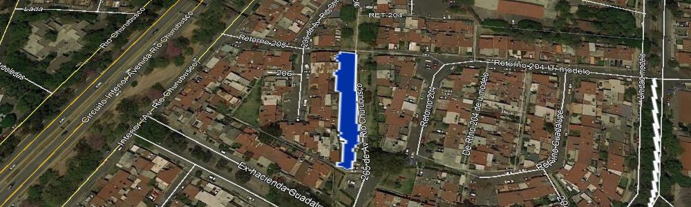
| Nombre del área verde: | UNIDAD HABITACIONAL (175) |
|
Mapa: |
Ver |
| Dirección: | 205 DE AV. RÍO CHURUBUSCO Y RTNO. 206 |
Superficie: | 1,017.10 m2 |
| Colonia: | MODELO |
Perímetro: | 234.26 m2 |
| Código postal: | 09089 |
Programa: | |
| Subclasificación: | Parques |
Decreto: | |
| Clasificación: | Parques, arboledas y alamedas |
Revegetada: | -, 0000-00-00 |
 |
| Nombre del área verde: | PARQUE (638) |
|
Mapa: |
Ver |
| Dirección: | AV. REPÚBLICA FEDERAL SUR |
Superficie: | 1,061.41 m2 |
| Colonia: | ZONA URBANA EJIDAL SANTA MARTHA ACATITLA SUR |
Perímetro: | 195.35 m2 |
| Código postal: | 09530 |
Programa: | |
| Subclasificación: | Terrenos baldíos |
Decreto: | |
| Clasificación: | Áreas verdes urbanas fragmentadas |
Revegetada: | -, 0000-00-00 |
 |
| Nombre del área verde: | ESCUELA SECUNDARIA TÉCNICA N° 103 (2201) |
|
Mapa: |
Ver |
| Dirección: | LAUREL ENTRE ÁLAMOS Y DEL ROSAL IZTAPALAPA |
Superficie: | 26.79 m2 |
| Colonia: | CAMPESTRE POTRERO |
Perímetro: | 24.19 m2 |
| Código postal: | 09637 |
Programa: | |
| Subclasificación: | Parques |
Decreto: | |
| Clasificación: | Parques, arboledas y alamedas |
Revegetada: | -, 0000-00-00 |
 |
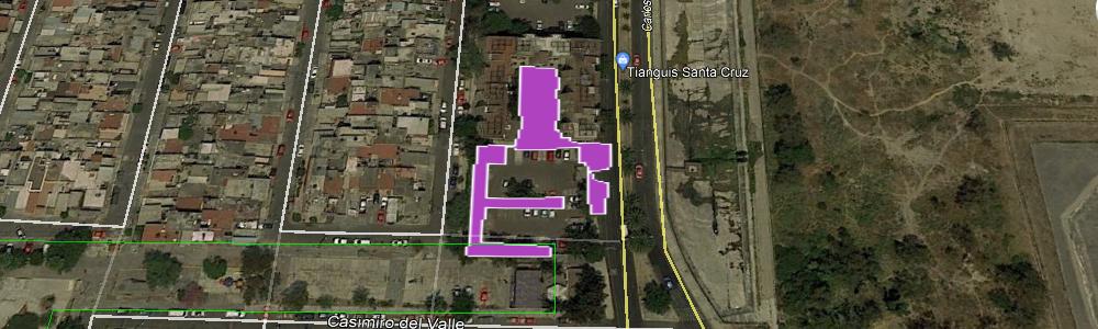
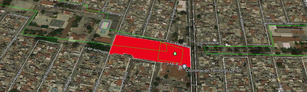
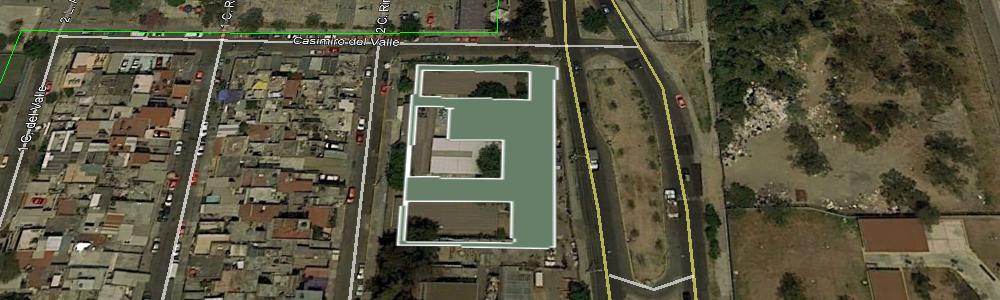
| Nombre del área verde: | PROF. SOCORRO LEGORRETA PALACIOS (1815) |
|
Mapa: |
Ver |
| Dirección: | C. 5 CASIMIRO DEL VALLE MZ23 LT28 |
Superficie: | 1,294.49 m2 |
| Colonia: | U.H. VICENTE GUERRERO |
Perímetro: | 443.81 m2 |
| Código postal: | 09200 |
Programa: | |
| Subclasificación: | Parques |
Decreto: | |
| Clasificación: | Parques, arboledas y alamedas |
Revegetada: | -, 0000-00-00 |
 |
| Nombre del área verde: | PARQUE (639) |
|
Mapa: |
Ver |
| Dirección: | AV. REPÚBLICA FEDERAL DEL SUR |
Superficie: | 124.26 m2 |
| Colonia: | ZONA URBANA EJIDAL SANTA MARTHA ACATITLA SUR |
Perímetro: | 47.02 m2 |
| Código postal: | 09530 |
Programa: | |
| Subclasificación: | Unidades habitacionales |
Decreto: | |
| Clasificación: | Equipamientos urbanos con vegetación |
Revegetada: | -, 0000-00-00 |
 |
| Nombre del área verde: | UNIDAD HABITACIONAL (174) |
|
Mapa: |
Ver |
| Dirección: | RTNO. AV EX HDA DE GUADALUPE Y RTNO. 206 |
Superficie: | 293.96 m2 |
| Colonia: | MODELO |
Perímetro: | 94.63 m2 |
| Código postal: | 09089 |
Programa: | |
| Subclasificación: | Parques |
Decreto: | |
| Clasificación: | Parques, arboledas y alamedas |
Revegetada: | -, 0000-00-00 |
 |
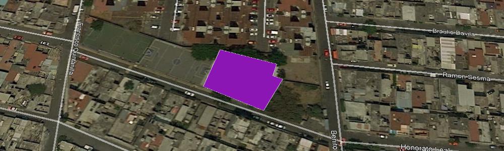
| Nombre del área verde: | CENTRO DE SALUD T-I HONORATO LEAL (63) |
|
Mapa: |
Ver |
| Dirección: | HONORATO LEAL 57 |
Superficie: | 752.01 m2 |
| Colonia: | LAS PEÑAS |
Perímetro: | 112.32 m2 |
| Código postal: | 09750 |
Programa: | |
| Subclasificación: | Parques |
Decreto: | |
| Clasificación: | Parques, arboledas y alamedas |
Revegetada: | -, 0000-00-00 |
 |
| Nombre del área verde: | ESCUELA SECUNDARIA DIURNA N° 137 DELFINA HUERTA LÓPEZ (1816) |
|
Mapa: |
Ver |
| Dirección: | GRAL. DONATO BRAVO IZQUIERDO S/N |
Superficie: | 733.61 m2 |
| Colonia: | CONSTITUCIÓN DE 1917 |
Perímetro: | 246.81 m2 |
| Código postal: | 09260 |
Programa: | |
| Subclasificación: | Instituciones académicas públicas |
Decreto: | |
| Clasificación: | Equipamientos urbanos con vegetación |
Revegetada: | -, 0000-00-00 |
 |
| Nombre del área verde: | ESCUELA SECUNDARIA DIURNA N° 137 DELFINA HUERTA LÓPEZ (1817) |
|
Mapa: |
Ver |
| Dirección: | GRAL. DONATO BRAVO IZQUIERDO S/N |
Superficie: | 134.63 m2 |
| Colonia: | CONSTITUCIÓN DE 1917 |
Perímetro: | 61.78 m2 |
| Código postal: | 09260 |
Programa: | |
| Subclasificación: | Parques |
Decreto: | |
| Clasificación: | Parques, arboledas y alamedas |
Revegetada: | -, 0000-00-00 |
 |
| Nombre del área verde: | PARQUE (640) |
|
Mapa: |
Ver |
| Dirección: | AV. REPÚBLICA FEDERAL DEL SUR |
Superficie: | 5,697.56 m2 |
| Colonia: | ZONA URBANA EJIDAL SANTA MARTHA ACATITLA SUR |
Perímetro: | 1,083.16 m2 |
| Código postal: | 09530 |
Programa: | |
| Subclasificación: | Parques |
Decreto: | |
| Clasificación: | Parques, arboledas y alamedas |
Revegetada: | -, 0000-00-00 |
 |
| Nombre del área verde: | ESCUELA SECUNDARIA DIURNA N° 152 VICENTE SUÁREZ (2064) |
|
Mapa: |
Ver |
| Dirección: | FRANCISCO NOBLE Y MANUEL CALERO |
Superficie: | 425.70 m2 |
| Colonia: | ZONA URBANA EJIDAL SANTA MARTHA ACATITLA SUR |
Perímetro: | 145.97 m2 |
| Código postal: | 09530 |
Programa: | |
| Subclasificación: | Instituciones académicas públicas |
Decreto: | |
| Clasificación: | Equipamientos urbanos con vegetación |
Revegetada: | -, 0000-00-00 |
 |
| Nombre del área verde: | ASISTENCIA SOCIAL CON VEGETACIÓN (172) |
|
Mapa: |
Ver |
| Dirección: | RTNO. CENTRAL PTE. Y AVENIDA UNIDAD MODELO |
Superficie: | 1,611.82 m2 |
| Colonia: | MODELO |
Perímetro: | 162.52 m2 |
| Código postal: | 09089 |
Programa: | |
| Subclasificación: | Parques |
Decreto: | |
| Clasificación: | Parques, arboledas y alamedas |
Revegetada: | -, 0000-00-00 |
 |
| Nombre del área verde: | ESCUELA PRIMARIA REPÚBLICA DE MADAGASCAR (1819) |
|
Mapa: |
Ver |
| Dirección: | C. IGNACIO LIC. VALLARTA Y MANLIO FABIO ALTAMIRANO |
Superficie: | 4,198.96 m2 |
| Colonia: | JACARANDAS |
Perímetro: | 801.08 m2 |
| Código postal: | 09280 |
Programa: | |
| Subclasificación: | Instituciones académicas públicas |
Decreto: | |
| Clasificación: | Equipamientos urbanos con vegetación |
Revegetada: | -, 0000-00-00 |
 |
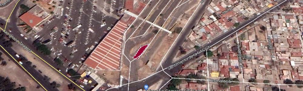
| Nombre del área verde: | CAMELLON ABARROTES (920) |
|
Mapa: |
Ver |
| Dirección: | ABARROTES Y VÍVERES Y CAZUELA |
Superficie: | 56,633.70 m2 |
| Colonia: | ÁREA FEDERAL CENTRAL DE ABASTOS |
Perímetro: | 1,553.09 m2 |
| Código postal: | 09040 |
Programa: | |
| Subclasificación: | Parques |
Decreto: | |
| Clasificación: | Parques, arboledas y alamedas |
Revegetada: | -, 0000-00-00 |
 |
| Nombre del área verde: | CAMELLON PROL. EMILIANO ZAPATA 4 RETORNO PONIENTE 4 (171) |
|
Mapa: |
Ver |
| Dirección: | PROL. EMILIANO ZAPATA 4 RETORNO PONIENTE 4, |
Superficie: | 101.03 m2 |
| Colonia: | HÉROES DE CHURUBUSCO |
Perímetro: | 69.61 m2 |
| Código postal: | 09090 |
Programa: | |
| Subclasificación: | Parques |
Decreto: | |
| Clasificación: | Parques, arboledas y alamedas |
Revegetada: | -, 0000-00-00 |
 |
| Nombre del área verde: | CAMELLON ANILLO DE CIRCUNVALACION (850) |
|
Mapa: |
Ver |
| Dirección: | ANILLO DE CIRCUNVALACION Y NARCISO MENDOZA |
Superficie: | 198.35 m2 |
| Colonia: | ZONA URBANA EJIDAL SANTA MARÍA AZTAHUACAN |
Perímetro: | 198.37 m2 |
| Código postal: | 09570 |
Programa: | |
| Subclasificación: | Instituciones académicas públicas |
Decreto: | |
| Clasificación: | Equipamientos urbanos con vegetación |
Revegetada: | -, 0000-00-00 |
 |
| Nombre del área verde: | ESCUELA PRIMARIA CENTENARIO HIMNO NACIONAL (170) |
|
Mapa: |
Ver |
| Dirección: | SUPER MANZANA 2DA. S/N |
Superficie: | 2,223.65 m2 |
| Colonia: | AV. UNIDAD MODELO |
Perímetro: | 725.31 m2 |
| Código postal: | 09090 |
Programa: | |
| Subclasificación: | Parques |
Decreto: | |
| Clasificación: | Parques, arboledas y alamedas |
Revegetada: | -, 0000-00-00 |
 |
| Nombre del área verde: | PARQUE (643) |
|
Mapa: |
Ver |
| Dirección: | AV. REPÚBLICA FED. DEL SUR |
Superficie: | 667.03 m2 |
| Colonia: | ZONA URBANA EJIDAL SANTA MARTHA ACATITLA SUR |
Perímetro: | 255.88 m2 |
| Código postal: | 09510 |
Programa: | |
| Subclasificación: | Parques |
Decreto: | |
| Clasificación: | Parques, arboledas y alamedas |
Revegetada: | -, 0000-00-00 |
 |
| Nombre del área verde: | PARQUE (1100) |
|
Mapa: |
Ver |
| Dirección: | C. 18 DE MARZO S/N |
Superficie: | 1,271.40 m2 |
| Colonia: | SAN MIGUEL TEOTONGO |
Perímetro: | 261.91 m2 |
| Código postal: | 09630 |
Programa: | |
| Subclasificación: | Parques |
Decreto: | |
| Clasificación: | Parques, arboledas y alamedas |
Revegetada: | -, 0000-00-00 |
 |
| Nombre del área verde: | PARQUE PATOLLI EL SALADO (1099) |
|
Mapa: |
Ver |
| Dirección: | ALEJANDRO AURA Y OYAMELES |
Superficie: | 11,913.65 m2 |
| Colonia: | ÁREA FEDERAL PARQUE ECOLÓGICO EL SALADO |
Perímetro: | 1,348.34 m2 |
| Código postal: | 09140 |
Programa: | |
| Subclasificación: | Parques |
Decreto: | |
| Clasificación: | Parques, arboledas y alamedas |
Revegetada: | -, 0000-00-00 |
 |
| Nombre del área verde: | PARQUE (796) |
|
Mapa: |
Ver |
| Dirección: | AV. STA- CRUZ MEYEHUALCO Y C. 7 |
Superficie: | 3,655.47 m2 |
| Colonia: | SANTA CRUZ MEYEHUALCO |
Perímetro: | 261.50 m2 |
| Código postal: | 09290 |
Programa: | |
| Subclasificación: | Unidades habitacionales |
Decreto: | |
| Clasificación: | Equipamientos urbanos con vegetación |
Revegetada: | -, 0000-00-00 |
 |
| Nombre del área verde: | CAMELLON AV. ANDRÉS MOLINA ENRÍQUEZ (644) |
|
Mapa: |
Ver |
| Dirección: | AV. ANDRÉS MOLINA ENRÍQUEZ Y PLAYA PIE DE LA CUESTA |
Superficie: | 2,546.91 m2 |
| Colonia: | SAN ANDRÉS TETEPILCO |
Perímetro: | 399.63 m2 |
| Código postal: | 09440 |
Programa: | |
| Subclasificación: | Unidades habitacionales |
Decreto: | |
| Clasificación: | Equipamientos urbanos con vegetación |
Revegetada: | -, 0000-00-00 |
 |
| Nombre del área verde: | UNIDAD HABITACIONAL (1830) |
|
Mapa: |
Ver |
| Dirección: | EDITORES Y SUBDIRECTORES |
Superficie: | 1,352.13 m2 |
| Colonia: | LOMAS ESTRELLA 2DA SECC |
Perímetro: | 164.30 m2 |
| Código postal: | 09640 |
Programa: | |
| Subclasificación: | Unidades habitacionales |
Decreto: | |
| Clasificación: | Equipamientos urbanos con vegetación |
Revegetada: | -, 0000-00-00 |
 |
| Nombre del área verde: | ESCUELA PRIMARIA PAULA ALEGRÍA GARZA (2081) |
|
Mapa: |
Ver |
| Dirección: | RAMÓN MÁRQUEZ, JOSÉ N. PRIETO Y BRIGADA ÁLVAREZ |
Superficie: | 115.75 m2 |
| Colonia: | ZONA URBANA EJIDAL SANTA MARTHA ACATITLA SUR |
Perímetro: | 42.99 m2 |
| Código postal: | 09530 |
Programa: | |
| Subclasificación: | Asistencia Social con vegetación CDMX |
Decreto: | |
| Clasificación: | Equipamientos urbanos con vegetación |
Revegetada: | -, 0000-00-00 |
 |
| Nombre del área verde: | UTOPÍA TECOLOXTITLAN (1098) |
|
Mapa: |
Ver |
| Dirección: | CULIACAN Y COLIMA |
Superficie: | 8,005.50 m2 |
| Colonia: | SAN SEBASTIÁN TECOLOXTITLA |
Perímetro: | 793.19 m2 |
| Código postal: | 09520 |
Programa: | |
| Subclasificación: | Unidades habitacionales |
Decreto: | |
| Clasificación: | Equipamientos urbanos con vegetación |
Revegetada: | -, 0000-00-00 |
 |
| Nombre del área verde: | UNIDAD HABITACIONAL (1832) |
|
Mapa: |
Ver |
| Dirección: | CINE MEXICANO Y AV. 11 |
Superficie: | 6,120.56 m2 |
| Colonia: | BENITO JUÁREZ |
Perímetro: | 1,626.48 m2 |
| Código postal: | 09898 |
Programa: | |
| Subclasificación: | Parques |
Decreto: | |
| Clasificación: | Parques, arboledas y alamedas |
Revegetada: | -, 0000-00-00 |
 |
| Nombre del área verde: | PARQUE (646) |
|
Mapa: |
Ver |
| Dirección: | AV. AMACUZAC Y PLAYA MIRADOR |
Superficie: | 1,866.44 m2 |
| Colonia: | SAN ANDRÉS TETEPILCO |
Perímetro: | 314.63 m2 |
| Código postal: | 09440 |
Programa: | |
| Subclasificación: | Arboledas |
Decreto: | |
| Clasificación: | Parques, arboledas y alamedas |
Revegetada: | -, 0000-00-00 |
 |
| Nombre del área verde: | PARQUE (1097) |
|
Mapa: |
Ver |
| Dirección: | CDA. CIRCUNVALACION Y ANILLO DE CIRCUNVALACIÓN |
Superficie: | 1,052.15 m2 |
| Colonia: | SANTA MARÍA AZTAHUACAN |
Perímetro: | 132.63 m2 |
| Código postal: | 09570 |
Programa: | |
| Subclasificación: | Unidades habitacionales |
Decreto: | |
| Clasificación: | Equipamientos urbanos con vegetación |
Revegetada: | -, 0000-00-00 |
 |
| Nombre del área verde: | UNIDAD HABITACIONAL (1833) |
|
Mapa: |
Ver |
| Dirección: | TECNICOS Y MANUALES |
Superficie: | 8,222.52 m2 |
| Colonia: | BENITO JUÁREZ |
Perímetro: | 1,919.70 m2 |
| Código postal: | 09898 |
Programa: | |
| Subclasificación: | Unidades habitacionales |
Decreto: | |
| Clasificación: | Equipamientos urbanos con vegetación |
Revegetada: | -, 0000-00-00 |
 |
| Nombre del área verde: | UNIDAD HABITACIONAL (167) |
|
Mapa: |
Ver |
| Dirección: | RTNO. 203 AVENIDA UNIDAD MODELO |
Superficie: | 367.37 m2 |
| Colonia: | MODELO |
Perímetro: | 137.00 m2 |
| Código postal: | 09250 |
Programa: | |
| Subclasificación: | Parques |
Decreto: | |
| Clasificación: | Parques, arboledas y alamedas |
Revegetada: | -, 0000-00-00 |
 |
| Nombre del área verde: | PARQUE (919) |
|
Mapa: |
Ver |
| Dirección: | AV. LEYES DE REFORMA Y ABARROTES Y VIVERES |
Superficie: | 17,237.12 m2 |
| Colonia: | PASEOS DE CHURUBUSCO |
Perímetro: | 1,069.71 m2 |
| Código postal: | 09030 |
Programa: | |
| Subclasificación: | Parques |
Decreto: | |
| Clasificación: | Parques, arboledas y alamedas |
Revegetada: | -, 0000-00-00 |
 |
| Nombre del área verde: | PARQUE (1096) |
|
Mapa: |
Ver |
| Dirección: | PROL. PLUTARCO ELÍAS CALLES Y HUMBERTO G. TAMAYO |
Superficie: | 11,607.83 m2 |
| Colonia: | CABEZA DE JUÁREZ X |
Perímetro: | 735.48 m2 |
| Código postal: | 09208 |
Programa: | |
| Subclasificación: | Parques |
Decreto: | |
| Clasificación: | Parques, arboledas y alamedas |
Revegetada: | -, 0000-00-00 |
 |
Fuente: Inventario de áreas verdes 2017
Regresar